Hi!
Here are some photos of Dundas. There are some interesting old buildings around the place that I think are worth showing. I took a walk around the block today and took some happy snaps.
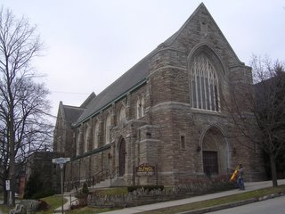
On Cross St, one intersection away from King St, is St Paul's church. (Does the 'St' make it a catholic church?) Not as impressive as some churches of course, but when you're from Canberra where few buildings are much older than 50 years, you notice anything that looks remotely "vintage". It's kinda nice to pass this on the walk to King Street.
If you want to follow where we are on a map, try using Google Local. It's a feature of Google that works in North America (and where else in the world? let us know if Google Local works in your area, I don't think it works in Aus yet). Go to
www.google.ca, type in "King St W & York Rd, Dundas, ON" and hit the Local button instead of doing a regular search. You should get a map of central Dundas. (I'm trying to avoid giving our

address on this blog, but if you know our address it should be pretty straightforward to see where we are - we're on the north side of the road ;-)
Next, here's the intersection of King and Cross, looking west along King St. King is the main drag in Dundas - most of the relevant shops are on King rather than being on Main (which also happens to meet King at this intersection). In picture is the Carnegie Gallery (white building - haven't been inside yet), the office of recently ousted federal member for ADFW (Ancaster - Dundas - Flamborough - Westdale riding) Russ Powers. He hasn't got around to taking the "MP" down from next to his name just yet...

Walking half a block up King, we come to some of our favourite shops. The Horn of Plenty is a converted cinema and you can still see the box office out the front. There's quite a lot of space inside for what started out as a health food shop. To the right is Cumbrae's organic butcher (black) and Picone's grocer (green). Picone's has some items we can't find anywhere else, like fresh basil that isn't brown, dry biscuits that aren't loaded with sugar, and the heretofore unknown Scottish breakfast tea. The shop with the red sign is a sports shop, which appears to sell mostly ice hockey sticks.

A block up King is the post office building which has a clock tower. It's now used for sorting the mail and isn't open to the public (note the fence around the perimeter, probably erected to discourage the homeless, but really making the place quite ugly and unfriendly).
There is continuous development and commerce along King St pretty much until you reach the escarpment. The Google map shows a freight train route, which runs along the side of the escarpment about half way up. It is a good indicator of where the escarpment is, at least for the north side of Dundas. At the top of the escarpment to the West is Flamborough, to the South is Ancaster. Dundas is surrounded on 3 sides (north, west, south) by the escarpment, and joins on to Westdale in the east where the university is. Development is more-or-less continuous between the towns, and in fact all of these towns are officially part of Hamilton now, where central Hamilton is further east beyond Westdale. We estimate Hamilton (including our area) is between 200,000 and 500,000 people based on what we've learned from the
recent election (four electorates, and our electorate has 100,000+ registered voters).
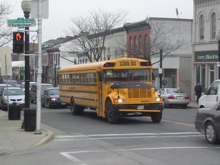
Here's an Otto-man bus - yes they really do look like this - and swarms of these can be seen going around the place a bit before 3pm each day. When you look at them side on, there is a really long overhang at the back of the bus, maybe 4 or 5 rows of seats worth. It looks like if you got enough people together at the back of the bus, it would flip up like a skateboard. If they are rear-wheel-drive, you could probably drop the clutch and do a wheelie!
There is more of Dundas to the south

and also to the north (before you hit the escarpment). On the corner of Main St and York Rd, a block south from King St, is the Town Hall. Amongst other things there is a public office where I picked up one of Hamilton's "blue bins" for recycling. They're trying to push recycling here, but I'm not sure how well it's catching on. The blue bins are crates, rather than full size rubbish bins, that would be full if you put say 4 pizza boxes in them. On the other hand, they collect every week, and they do special collections throughout the year, from old furniture to discarded Christmas trees.
If

I turn around on the corner of Main and York and look north up York, I see what's in the next photo. This is a reasonably typical Dundas street, with individual houses and high rise apartments built right next to each other in haphazard fashion. (Remember, I grew up in a town that was planned from conception!) The apartment blocks like the brown building on the left are pretty common around the place. Yes, they're ugly, but the fact that they increase the population density around here is good because there's a half decent chance of hanging on to good shops and public transport.
The day is pretty dreary today, overcast. But that
means it isn't freezing. It's 6 degrees when early February might be 10 degrees less in your average winter.
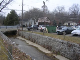
This last photo is looking up the stream toward York Road running north (right) - south (left). You can just make out a road railing (look for a silver line) in the top right of the picture. This is Helen Street which runs up and across a small ridge and ends at the Cemetery further along York Road. I found that this makes for quite a nice walk, and I'm looking forward to further exploring the views in the area.
Well, that's a short tour of the centre of Dundas. I'll have to go back and get a shot of King Street at night when they turn the lights on - very pretty. And if it ever snows again, it'll probably be even prettier! It has snowed seriously once since we've been here - twice at a stretch if you count the meagre covering we got in early Jan.
So long, and watch this space!

